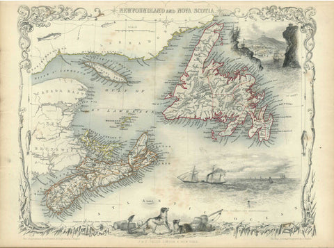
Nova Scotia and Newfoundland, 1851, Tallis
Description:
ORIGINAL ANTIQUE MAP
Nova Scotia and Newfoundland
Mapmaker / Publisher: Tallis, John
Date: 1851
Size: 14.5" x 10.5"
An attractive steel engraved map of Nova Scotia and Newfoundland with parts of New Brunswick, Labrador, and Gulf of St. Lawrence. The map includes vignettes of Halifax, steam and sailing ships in the Cod Fishery off Newfoundland, and the seals of both provinces. The decorative border features ice and fish caught on fishing lines. Tallis was one of the last great decorative mapmakers. His maps are prized for the wonderful vignettes of indigenous scenes and people. Original hand colored outline.
Certificate of Authenticity is provided.
We think you may also like...
-
 $2,100.00