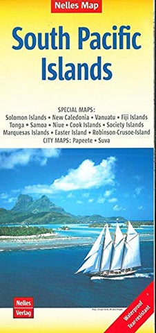
South Pacific Islands Nelles Map
Description:
The islands of the South Pacific on a double-sided map (unfolds to 102 x 50 cm / 40" x 20") providing an overview of the whole region at a scale 1:13,000,000 * Special maps: Solomon Islands, New Caledonia, Vanuatu, Fiji Islands, Tonga, Samoa, Niue, Cook Islands, Society Islands, Marquesas Islands, Easter Island, Robinson-Crusoe-Island * City maps: Papeete, Suva * Topography of the islands is shown by bold relief shading with spot heights. Road network includes minor roads and tracks* National parks, protected areas and places of interest are prominently highlighted * Each panel has margin ticks with latitude and longitude.
Updated edition 2019