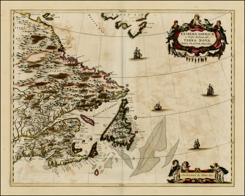
Extrema Ameicae, Terra Nova, Blaeu, 1670
Description:
SHIPPING IS NOT INCLUDED - Please contact for a quote.
ORIGINAL ANTIQUE MAP
"Extrema Americae Versus Boream ubi Terra Nova Nova Francia"
Mapmaker / Publisher: Blaeu, Joan
Date: 1670
Size: 25" x 20"
This beautiful map of the Canadian Maritimes is based on Samuel de Champlain’s great map of 1632, and augmented with place names from De Laet and Jansson. This is Blaeu’s only map of Canada. It shows Nova Scotia, Newfoundland, the Gulf of St. Lawrence, Labrador and the Davis and Hudson Straits, as well as, the southern tip of Greenland, and a portion of northern Maine. The map appears in only a few of Blaeu’s Atlas Maior after 1662 and is thus very uncommon.
Certificate of Authenticity is provided.
We think you may also like...
-
 $2,100.00