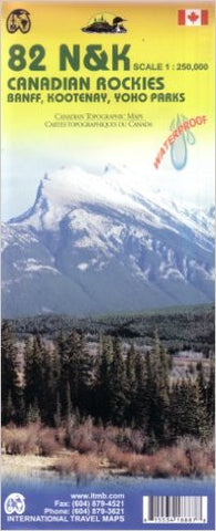
Canadian Rockies ITM Travel Map
Description:
Folded Map edition (September 2008)
Banff, Kootenay, Yoho Parks.
A waterproof and double sided road map of the Canadian Rockies to plan your trip, to prepare your itinerary, and to travel independently in part of the country. Scale 1:250 000
Touristic information: viewpoints, points of interest, RV and camping, recreational sites, picnic areas, parking, wilderness parks, shelters, accommodation, alpine huts, warden/ranger stations, cross country skiing, canoeing, paddling, hiking, interpretive trails, horseback riding, mountain climbing, mountain biking, golf courses, hang gliding, snowmobiling.
We think you may also like...
-
 $19.95
 -
 $24.95