Description:
SHIPPING IS NOT INCLUDED - Please contact for a quote.
ORIGINAL ANTIQUE MAP
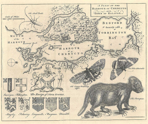
A Plan of the Harbour of Chebucto and Town of Halifax
Mapmaker / Publisher: Harris, Moses
Date: 1750
Size: 11" x 9"
A black and white copper-engraved map by Moses Harris depicts Halifax and its harbor, from “Cornwallis” (now McNab) Island to the head of Bedford Basin (formerly called “Torrington Bay”). What is now the North West Arm of the harbor is here “Sandwich or Hawk's River”. Moses Harris was a noted eighteenth century entomologist who had training as a surveyor and served in that capacity when he came with Cornwallis in 1749 and laid out the new town of Halifax in that same year. This famous map was published in July of 1750 in the “Gentleman´s Magazine” and is known as the "Porcupine Map" due to the eccentric engraving of a porcupine in the lower right hand corner. In addition to the porcupine also shown are “The Musk Beetle”, two butterflies “The Orange Underwing Tyger” and “The White Admirable”, the seal of Nova Scotia, and the crests of seven families.
Certificate of Authenticity is provided.
We think you may also like...
-
 $22.99