Description:
REPRODUCTION
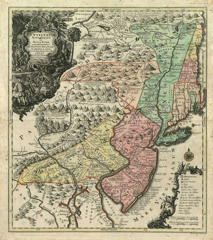
Pensylvania Nova Jersey et Nova York cum Regionibus ad Fluvium Delaware in America Sitis
Mapmaker / Publisher: Seutter/ Lotter
Date: 1750
Size: 21" x 23.5"
This is a remarkable pre-revolutionary war era map based on Lewis Evans´ map of 1749, one of the first and most important maps of the region. This map shows the states of New York, Massachusetts, New Jersey, Pennsylvania and Hampshire in color. The neighboring states are outlined. The top left has a very detailed title cartouche with a European in contemporary clothing centered with workers. Native wildlife fills the bordering area. This German version had wider circulation than the Evans’ map and therefore had a significant influence on the European view of the colonies. This map was engraved for Matthias Seutter (1678-1757) by Lotter.
We think you may also like...
-
 $2,100.00