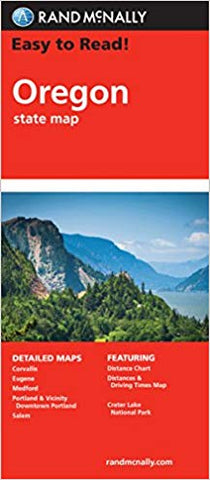
Oregon Rand McNally State Map
Description:
Rand McNally's Easy To Read State Folded Map of Oregon is offering unbeatable accuracy and reliability at a great price. Trusted cartography shows all Interstate, U.S., state, and county highways, along with clearly indicated parks, points of interest, airports, county boundaries, and streets. Easy-to-use legend and detailed index make for quick and easy location of destinations.
Updated edition 2013
We think you may also like...
-
 $37.99
 -
 $13.95