Description:
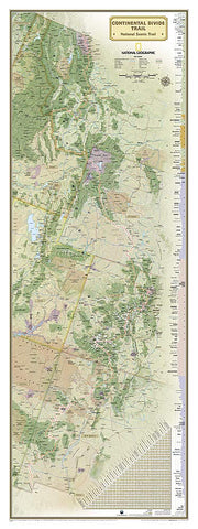
Title: Appalachian Trail
Size: 18" x 48"
Scale: 1:1,900,000
Publisher: National Geographic
National Geographic's wall map of the Continental Divide trail is an iconic representation of this magnificent national scenic trail, running for over 3,100 miles from Mexico to Canada through New Mexico, Colorado, Wyoming, Idaho, and Montana. This beautiful poster is packed with information on the trail, including the elevation profiles of its peaks and valleys and an informative mileage chart that shows the distance between key locations.
Embellished nameplates of the states through which the trail runs contrast beautifully with the green tones of the land. An informative mileage chart shows the distance between key locations, and highlighted on this map are National Forests, National Park Service lands, State Forests and Parks, passes, and major highways and interstates. Points of interest include lodges and campgrounds near the trail.
We think you may also like...
-
 $38.95
 -
 $13.95