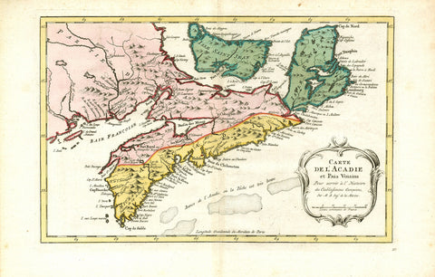
2510/2 Nova Scotia, 1773, Harrevelt
Description:
REPRODUCTION
Carte de L´Acadie et Pais Voisins
Mapmaker / Publisher: Harrevelt, E. van
Date: 1773
Size: 16" x 10"
Uncommon edition of this fine map of Maritime Canada. This is an intermediate state between Kershaw 785 and 786; the map has an engraved nr.37, Louisburg and Baie Chedabouctou remain but ou Milford have been deleted. From "Atlas Portatif..." With French text in title cartouche and an additional title in Dutch underneath the map. Prepared by Jacques Nicolas Bellin (1703-1772); one of the most important and proficient French cartographers of the mid-eighteenth century.