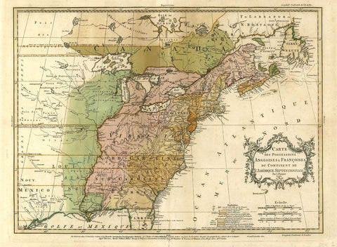
2493/1 Eastern Canada and Eastern US, 1756, Palairet
Description:
REPRODUCTION
Carte des Possessions Angloises & Francoises du Continent de l´Amerique Septentrionale
Mapmaker / Publisher: Palairet, Jean
Date: 1756
Size: 29" x 22"
This fascinating map is the second state of one of the best maps of the colonies on the eve of the French and Indian War. Mr. Palairet was the Agent to the States General in London. In 1755 he published the pamphlet "A Concise Description of the English and French Possessions in North America." The map was engraved by Thomas Kitchen and intricately coloured to show the disputed lands, forts, roads, and the extend of settlement in the region. Embellished with a delicately engraved title cartouche.