Description:
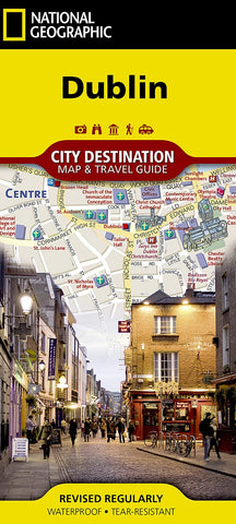
Dublin City Destination map is a complete travel guide to Ireland's capital city. The front side presents a detailed road network with designations routes, main and secondary roads, one way streets and pedestrian areas. It features hundreds of points of interest, with a multi-language legend, metro and train stations, hotels, parks, hospitals, police stations, theaters and monuments. Many top attractions are depicted in 3D, like the Dublin Castle, National Museum and St. Patrick's Cathedral.
The reverse side has an overview map of Ireland. A user-friendly index of streets, hotels, parks, public buildings and other points of interest along with a rail map, diagram of Dublin airport and overview of the transit system will help you plan your route. Waterproof, tear-resistant map is printed on durable synthetic paper.
Updated edition Nov 2018
We think you may also like...
-
 $22.99