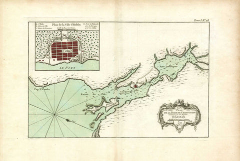
Map of Halifax Harbour, Bellin, 1763
Description:
SHIPPING IS NOT INCLUDED - Please contact for a quote.
ORIGINAL ANTIQUE MAP
Plan de la Baye de Chibouctou nommee par les Anglois Halifax
Mapmaker / Publisher: Bellin, Jaques Nicolas
Date: 1763
Size: 18" x 12"
Beautiful copper engraved map of the vicinity of Halifax Harbour from Chebucto Head to the head of Bedford Basin. Oriented with north to the lower right. Inset of "Plan de la Ville d´Halifax" showing the fort and government buildings. Original colour delineates the water and city plan. The decorative cartouche is uncoloured. Jaques Nicolas Bellin (1703-1772) was the first hydrographic engineer of the Depot der cartes.
Certificate of Authenticity is provided.
We think you may also like...
-
 $22.99