Description:
SHIPPING IS NOT INCLUDED - Please contact for a quote.
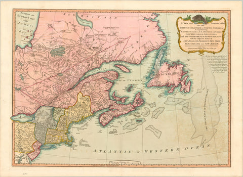
ORIGINAL ANTIQUE MAP
"A New and Correct Map of the British Colonies in North America Comprehending Eastern Canada with the Adjacent States of New England, Vermont, New York, Pennsylvania and New Jersey."
Mapmaker / Publisher: Laurie & Whittle
Date: 1794
Size: 28" x 21"
A nice example of Laurie & Whittle’s map of Canada and the Northeastern United States, extending from Hudson and James Bays to Newfoundland and the Grand Bank, and to Delaware Bay, the Upper Chesapeake, Pennsylvania and Lake Ontario. Interesting annotations throughout; rich with Indian details; the great fishing banks are graphically depicted. The cartouche includes a Beaver at the top. The note below the cartouche explains the control of various strategic fishing islands off the coast of Newfoundland. Hand coloured.
Certificate of Authenticity is provided.
We think you may also like...
-
 $22.99