Description:
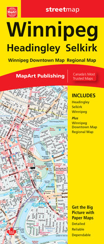
The Winnipeg folded map includes detailed city mapping of Winnipeg and Selkirk at 1:30,000, a map of downtown Winnipeg at 1:20,000 and a regional map of the Winnipeg area at 1:500,000. The city mapping includes street indexes of each community and a legend. Features Trans-Canada highway, Yellowhead Route, divided highways, major and regional roads, main thoroughfares, minor streets, lanes, pedestrian streets, one way streets, railways, VIA Rail stations, Southwest Transitway, municipal boundaries, recreation trails, parks / conservation areas, golf courses, National Defence, hospitals, tourist information centers, police stations, fire halls, municipal / regional building, courthouses, libraries, points of interest, national parks / historic sites, arenas, pools, baseball, soccer, tennis, campgrounds, cross-country skiing, and more.
Updated edition 2023