Description:
SHIPPING IS NOT INCLUDED - Please contact for a quote.
ORIGINAL ANTIQUE MAP
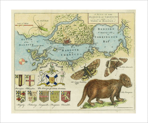
A Plan of the Harbour of Chebucto and Town of Halifax
Mapmaker / Publisher: Harris, Moses
Date: 1750
Size: 11" x 9"
A very attractive and early map of the town of Halifax and vicinity by Moses Harris. This copper-engraved map depicts Halifax and its harbor from “Cornwallis” now McNab Island to the head of Bedford Basin formerly called “Torrington Bay”. What is now the North West Arm of the harbor is here “Sandwich or Hawk's River”. The map is decorated with coats of arms, the picturesque crests of seven families, the Ensign of Nova Scotia, “The Musk Beetle”, two butterflies “The Orange Underwing Tyger” and “The White Admirable” and “The Porcupine”. This famous map was published in July of 1750 in the “Gentleman´s Magazine” and is known as the "Porcupine Map" due to the eccentric engraving of a porcupine in the lower right hand corner.
Certificate of Authenticity is provided.