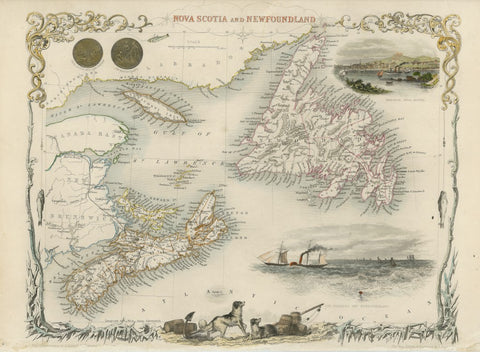
Nova Scotia and Newfoundland, 1850, Tallis
Description:
ORIGINAL ANTIQUE MAP
Nova Scotia and Newfoundland
Mapmaker / Publisher: Tallis, John
Date: 1850
Size: 14.5" x 10.5"
This is a decorative map of Nova Scotia and Newfoundland, including parts of New Brunswick and Labrador, published in The Illustrated Atlas. The map includes vignettes of Halifax, steam and sailing ships in the Cod Fishery off Newfoundland, the seals of both provinces, and a pair of dogs with barrels and an anchor. The decorative border features ice and fish caught on fishing lines. Map drawn and engraved by J. Rapkin, illustrations drawn by A. Fussell and engraved by J. Rogers. Hand color.
Certificate of Authenticity is provided.
We think you may also like...
-
 $11.99